
For many industrial organizations, inventory visibility ends where the warehouse ends.
Once materials, equipment, pipes, structural steel, pallets, containers, or spare parts are moved into outdoor stockyards or laydown yards, tracking them becomes significantly more difficult. Inventory may be stored correctly one day, relocated the next, and become nearly impossible to find a few weeks later.
The result is familiar across mining, construction, oil and gas, utilities, and heavy manufacturing. Teams spend valuable time searching for inventory instead of using it. Duplicate purchases become common because existing materials cannot be located. Maintenance and construction activities are delayed while employees physically inspect large outdoor storage areas.
This is why GPS yard mapping inventory has become an increasingly important capability for industrial organizations. Instead of relying on handwritten maps, employee memory, or manual yard inspections, GPS yard mapping inventory provides precise digital location information for inventory stored across large outdoor areas.
Combined with RFID, mobile technology, and real-time inventory visibility, GPS mapping transforms outdoor inventory management from a reactive process into a strategic operational advantage.
In this guide, we'll explore how GPS yard mapping inventory works, why traditional yard management methods fall short, and how industrial organizations can improve inventory visibility across stockyards and laydown yards.
GPS yard mapping inventory is the process of digitally mapping outdoor inventory locations using GPS coordinates, mobile devices, RFID technology, and centralized inventory management software.
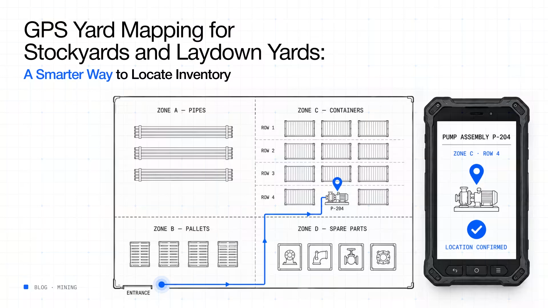
Rather than simply recording that an item exists somewhere in a yard, GPS mapping identifies its precise storage location within a digital map. Employees can search for inventory and immediately navigate to its location instead of manually walking through storage areas.
For organizations managing thousands of inventory items across large outdoor facilities, this level of visibility dramatically reduces search time while improving inventory accuracy. Unlike traditional yard management, GPS yard mapping inventory provides continuous visibility into inventory location as materials move throughout operational areas.
Warehouses are designed for inventory control. Stockyards and laydown yards are not. Outdoor inventory environments change constantly as materials arrive, projects evolve, maintenance activities occur, and operational priorities shift.
Large industrial organizations often store inventory across:
Inventory frequently moves between these locations without consistent documentation. After several weeks or months, locating specific inventory becomes increasingly dependent on employee knowledge rather than accurate inventory records.
As experienced personnel leave or projects change, that knowledge disappears. This is where GPS yard mapping inventory becomes essential.
Organizations managing outdoor inventory typically experience several recurring problems.
Employees often know inventory exists somewhere within a yard but cannot identify its exact location. Searching large stockyards manually wastes valuable labor hours and delays maintenance, production, or construction activities.
Inventory is regularly moved to create space for new deliveries, improve equipment access, or support changing operational priorities. Unless these movements are recorded immediately, inventory records quickly become inaccurate.
When inventory cannot be located quickly, procurement teams often assume it has been consumed or lost. Replacement inventory is purchased while the original materials remain somewhere within the yard. This increases inventory investment without improving inventory availability.
Unlike warehouses with aisles and shelving systems, outdoor yards may cover hundreds of acres. Without digital location tracking, even experienced employees can spend significant time locating materials. These challenges make GPS yard mapping inventory increasingly valuable for organizations managing extensive outdoor operations.
If your team spends more time searching for inventory than using it, it's time to rethink outdoor inventory visibility. Discover how Scatterlink helps organizations digitize stockyards and laydown yards.
The greatest advantage of GPS yard mapping inventory is simple. Employees no longer search. They navigate. Instead of relying on memory or verbal directions, warehouse personnel, maintenance teams, and project managers can open a digital map and immediately identify where inventory is stored.
This improves operational efficiency in several ways. Inventory searches become significantly faster. Equipment downtime caused by missing inventory decreases. Project teams retrieve materials more efficiently.
Warehouse personnel spend less time responding to location requests.Procurement gains confidence that inventory has truly been exhausted before placing new purchase orders. Across large industrial sites, these operational improvements translate directly into higher productivity and lower operating costs.
Many organizations already own the inventory they need. However, the challenge is finding it. Without visibility into outdoor inventory locations, materials often remain unused while identical inventory is purchased elsewhere. GPS yard mapping inventory improves inventory utilization by making every inventory item searchable according to its precise location.
Instead of purchasing additional inventory, organizations can redistribute existing materials between projects, maintenance activities, or operational sites. This reduces carrying costs while improving inventory turnover.
GPS identifies where inventory is stored across the yard. RFID identifies what inventory is located there. Together, these technologies create a powerful inventory management solution.
RFID tags attached to inventory allow organizations to identify materials quickly without manual data entry, while GPS mapping records their physical location within the yard. When inventory moves, both the inventory record and location update simultaneously.
This combination significantly improves GPS yard mapping inventory by reducing manual inventory transactions while maintaining accurate location information. Employees spend less time searching, inventory records remain current, and operational decisions become faster and more reliable.
Laydown yards are designed to provide temporary storage for materials, equipment, and components until they are needed. However, as projects evolve, these yards often become increasingly difficult to organize. New deliveries arrive daily, materials are relocated to create space, and temporary storage areas become permanent without being documented.
Over time, inventory visibility begins to decline.
Materials may still be available, but employees no longer know exactly where they are stored. Project teams spend valuable time searching for inventory, while procurement departments purchase replacements because existing stock cannot be located quickly.
GPS yard mapping inventory addresses this challenge by replacing static yard layouts with dynamic digital maps. Every storage zone, inventory movement, and location update is reflected within a centralized system, allowing employees to locate materials in minutes rather than hours.
Instead of depending on employee memory, organizations develop a repeatable and standardized approach to managing outdoor inventory.
Outdoor inventory management rarely happens from an office.
Warehouse personnel receive deliveries in stockyards. Maintenance teams retrieve spare parts from outdoor storage areas. Construction supervisors issue materials directly from laydown yards, and equipment operators relocate inventory throughout the day.
A modern GPS yard mapping inventory solution should support these activities where they occur.
Mobile inventory applications allow employees to search inventory, confirm locations, receive materials, transfer inventory, and update storage locations directly from smartphones or rugged handheld devices. This reduces paperwork while ensuring inventory records remain current.
For organizations operating in remote environments, offline-first mobile capability is equally important. Employees can continue recording inventory transactions without network connectivity, with updates synchronizing automatically once connectivity is restored.
This ensures outdoor inventory remains visible regardless of operating conditions.
Knowing where inventory is located is valuable.Understanding how inventory moves across outdoor storage areas is even more valuable. When organizations implement GPS yard mapping inventory, they begin collecting operational data that supports better inventory planning.
For example, inventory intelligence can reveal:
These insights help organizations optimize yard utilization while reducing unnecessary material handling and inventory search time.
Instead of simply managing storage locations, businesses begin improving how outdoor inventory supports operational performance.
Outdoor inventory shouldn't become invisible simply because it's outside the warehouse. Learn how Scatterlink helps organizations digitize stockyards and improve inventory visibility across every outdoor location.
Scatterlink's Inventory Intelligence Platform combines GPS mapping, RFID technology, barcode scanning, IoT devices, mobile inventory applications, and ERP integration to provide complete visibility across warehouses, stockyards, laydown yards, and remote operational sites.
With GPS yard mapping inventory, employees can search for inventory and immediately identify its exact location on a digital yard map. RFID technology automatically identifies tagged inventory, while mobile devices allow users to update inventory locations directly from the field as materials move between storage areas.
This combination provides significantly greater visibility than traditional yard management methods. Warehouse teams spend less time searching for inventory. Maintenance personnel locate critical spare parts faster. Construction teams retrieve materials without unnecessary delays.
Procurement professionals make purchasing decisions using accurate inventory information rather than assumptions. Scatterlink's offline-first mobile capability also ensures inventory transactions continue uninterrupted in remote locations where network connectivity may be limited. Once connectivity returns, inventory updates synchronize automatically, maintaining a single source of truth across the organization.
Designed for frontline operations, the platform requires minimal training and integrates naturally into existing workflows. Rather than adding administrative work, Scatterlink delivers accurate, intelligent, and actionable inventory information for warehouse personnel, maintenance teams, procurement professionals, project managers, and executive leadership.
Looking to eliminate inventory search time across your stockyards and laydown yards? Discover how Scatterlink combines GPS mapping, RFID, and real-time inventory intelligence to help industrial organizations locate inventory faster and operate more efficiently.
Outdoor inventory presents challenges that traditional warehouse inventory systems were never designed to solve. Large stockyards, constantly changing storage locations, equipment movement, and manual location tracking often reduce inventory visibility just when organizations need it most.
GPS yard mapping inventory provides a practical solution by giving every inventory item a searchable digital location. Combined with RFID, mobile inventory management, and real-time inventory intelligence, organizations can significantly reduce inventory search time, improve inventory utilization, and make faster operational decisions.
The benefits extend well beyond locating materials. Better outdoor inventory visibility improves maintenance planning, reduces duplicate purchases, increases yard efficiency, and helps organizations maximize the value of the inventory they already own.
For mining, construction, oil and gas, utilities, and other asset-intensive industries, GPS yard mapping inventory is becoming an essential capability for modern inventory management and operational excellence.
GPS yard mapping inventory is the process of digitally mapping the location of inventory stored in outdoor stockyards, laydown yards, and storage areas using GPS technology, mobile devices, RFID, and inventory management software.
Mining, construction, oil and gas, utilities, heavy manufacturing, ports, logistics, and infrastructure companies all benefit because they manage large volumes of inventory across extensive outdoor storage areas.
GPS yard mapping inventory helps organizations locate materials faster, reduce inventory search time, improve inventory accuracy, optimize yard layouts, reduce duplicate purchases, and improve inventory utilization.
Yes. Combining GPS with RFID provides both precise inventory location and automatic inventory identification, creating a more complete outdoor inventory management solution.
Outdoor storage areas are constantly changing. GPS yard mapping inventory ensures inventory locations remain visible and searchable, reducing operational delays and improving productivity across large industrial sites.
%20(1).avif)
.avif)
%20(1).avif)